The Ebb and Flood of Baltimore’s Relationship with a Local Waterway in the Valley
The following text is a summarized version of a report on the Jones Falls Expressway in Baltimore, MD and the potential of its removal. Written by Megan Schwartz
Jones Falls River is a small stream that extends across the fall line of the Piedmont plateau and the Atlantic Coastal Plain. The southern portion of the Jones Falls estuary feeds directly into the Baltimore Harbor, part of the larger Chesapeake Bay Watershed which spans six states, from New York down to Virginia.
Cities throughout history have always had strong relationships with nearby bodies of water. Baltimore was no different. The Baltimore Harbor is what helped Baltimore to become such a prominent city in the early days of its development and the Jones Falls River became a precious resource. Development was built directly upon the banks of the River. This human intrusion on a natural and wild resource began to create problems. Spewing toxic waste from the mills upstream, the River became hazardous to the health of Baltimore’s population. Furthermore, with the surrounding banks no longer able to absorb rising waters, the Jones Falls would flood regularly. The Jones Falls would soon become a sewer, and after numerous disasters- including a fire which spread on the surface of the water- Baltimore officials decided it would be best to bury the River.
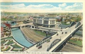
The first talk of burying the Jones Falls River came in 1817 from British-born American architect, Benjamin Latrobe. This early suggestion was later repeated by inventor and mechanic, Ross Winans, in 1837 [Swope 69]. Despite these early recommendations, nothing more was to be said about it for another 70 years. Then, in 1907, Calvin Hendrick, Chief Engineer of Baltimore’s Sewerage Commission, suggested a series of conduits to contain the waterway in hopes of putting an end to its “deadly overflows.” In 1912, under Mayor James H. Preston, the Jones Falls River was finally channeled into a series of underground conduits at a cost of $2 million. When the project was completed, 1 ¼ mile of the river was buried in a culvert, and the city gained 600,000 square feet of usable land, which would become a new road, respectfully named the Fallsway. At the Fallsway’s dedication ceremony, the new Mayor Mahool expressed hope that the modern road would “wipe out the barrier that for years has separated East Baltimore from West Baltimore” [Dorsey]. Little did he, or anyone else, know that the Fallsway’s creation would eventually lead to the establishment of an entirely new barrier; one that would be much more difficult to cross.The Expressway Act of 1947 was a turning in Maryland’s transportation history. Immediately followed by the Baltimore Master Transportation Plan of 1949, the Expressway Act established controlled-access expressways in Maryland, and ignited the rapid highway growth that would ultimately lead to the creation of the Jones Falls Expressway. In time, the Jones Falls Expressway would grow to span a total length of 9 miles, 7 of which are within city limits.
Where the river is not buried under the Fallsway, it is shadowed by the elevated Jones Falls Expressway rising above [Dickinson]. The spaces beneath the roadway, however, occasionally do lend themselves to positive social opportunities. Dating back to 1977, the Baltimore Farmers’ Market and Bazaar, which provides fresh produce to city residents, moved under the expressway’s shelter in 1985. Another pleasant surprise comes along while atop the roadway. The Baltimore skyline is approached from a perspective not seen elsewhere in the city. American urban planner and author, Kevin Lynch, points out that many people often recount pleasant experiences when traveling into a city on an elevated highway, from where they might be able to see prominent landmarks in the skyline [Lynch 49]. These few redeeming elements, however, do not come close to compensating for the destruction the highway had created in Baltimore. If the river had been the city’s spine, the highway had become a painful gash in the city’s skin.In the United States, and more and more elsewhere as other countries follow the American way, automobiles are becoming an integral element in city planning. All the while, city populations are declining. People would be fair- and right- to blame the urban highways. Highways do not promote local circulation; their main purpose is to get people in and out of town without any trouble. Many would trace this mobility issue back to the automobile. Cars have a destabilizing effect on cities. Richard Register, a California-based architect who is a leading figure in the present-day Eco-Cities movement, believes that the automobile is responsible for “destroying the balance between the inward and outward forces of the city’s growth and metabolism” [Register 141]. In 1960, Baltimore’s population was 939,024. Fifty years later, the population has fallen to 620,961. There has been significant decline since the 1970s, around the same time that the Jones Falls Expressway was created. Automobiles presented the opportunity for sprawl, one of the principle reasons for population declines within cities. Approximately one hundred thousand cars travel on the JFX each day. Although this roadway serves the city by bringing suburban residents directly into its central district, it also severs the city in two. Not to mention, the highway is the reason most of those people moved to the suburbs to begin with. The area surrounding the Jones Falls Expressway suffered depopulation and suburban flight soon after the highways completion. It was an “outward-exodus” [Counihan]. In constructing its urban highways, Baltimore, like many other cities in America, “seemed to collaborate in its own demise” [Kay 233].
The opportunity for change in Baltimore will present itself soon enough. “Our infrastructure is falling faster than our capacity to restore it” [Kay]. That may sound worrisome, but it is actually a blessing in disguise. Both the Fallsway and the Jones Falls Expressway will be in need of repair and upgrades in the coming years, and one common question has been repeatedly asked in recent years: why should the city spend money to maintain such debilitating structures when they could “pursue an alternative strategy that creates a connection between downtown and Hopkins…”[Wilk]? The alternative, of course, is to de-pave.
The idea is not as farfetched as it may seem. In the last decade, it has been proposed for the Jones Falls Expressway multiple times. Walter Sondheim was a well-known figure in Baltimore. He was a guiding influence in Baltimore’s development and renewal. When asked in 2003 what his dream development project was, Sondheim was quoted as saying he had hoped to see the Jones Falls Expressway, from the Guilford Avenue exit down, removed.
“It serves no purpose. It’s a barrier in the city. We should extend the President Street boulevard right up to the expressway at the Guilford Avenue exit because that exit there is down at ground level… I think taking it down would open up the city from east and west.”[1]
Two years prior to his death in 2007, Sondheim was involved in an official city proposal seriously considering the removal of the Jones Falls Expressway. Indeed, Sondheim was not the only one who felt the JFX was “a barrier in the city.” That viewpoint has been shared by many. “Even before it opened, the expressway’s southern edge drew criticism for creating a barrier between downtown and the less densely developed land to the East.” [Wilk]
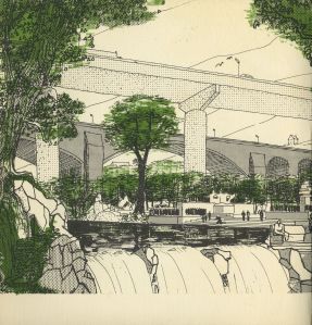
With the same money that is already set aside for repair, it is possible to remove portions of the JFX and excavate the Jones Falls River instead. This process has the potential of transforming the barrier into a seam. A seam is found in the city when an edge between two regions functions as a means for joining the two together. Daylighting, the act of re-opening a waterway that has previously been buried will cost less than the replacement of the same structure. The benefits of such an alternative will be invaluable in Baltimore City.

Page 10 of the “Plan for the Jones Falls Valley” Document, showing an idealistic vision of the Jones Falls Expressway
Charm City lost its charm when the highways came along. Removing the highways would restore a sense of place in the city. The space used for the JFX that serves the farmers’ market is a happy accident, but it’s not reason enough to let the highway be. Removing the JFX could create opportunities for better spaces for public interaction. By daylighting the Jones Falls and restoring it to its original state, Baltimore can remediate the local ecosystem [Dickinson]. The Jones Falls Valley may still become the urban park or greenway that has been desired for over a century. New architecture surrounding the river could be wrapped in the shells of the old industrial mills. Following the examples of places like Clipper Mill, the Jones Falls Valley corridor could be revitalized and livable. Reviving the Jones Falls Valley is necessary for the stability of our ecosystem. The same process, in addition, provides opportunities for recreation and education while increasing the scenic beauty of the city. An urban greenway of this magnitude will link parks and paths for pedestrians and bicyclists, just as Olmsted’s plan for the Emerald Necklace does in Boston.
Such improvements are the driving aspects behind holistic urbanism. Holistic urbanism is the promotion of whole city health; this means the health of both the residents and the environment. Cities must be seen as places for numerous types of people rather than a place to serve one class or group. The latter school of thought is why hundreds of thousands of people had been removed from their homes, all in the name of urban renewal. “The city is not built for one person, but for great numbers of people, of widely varying backgrounds, temperaments, occupations, and class” [Lynch 110]. The same holds true for nature as well. Cities need “not only aim to give human beings the right of way, but to give animals and the environment their place” [Kay, 344]. Modern planning movements, such as the Advocacy Planning approach, work to benefit as many people as possible. In more recent years, concepts such as New Urbanism, New Pedestrianism, and similar ideas slowly move away from the auto-centric manner of thinking and towards holistic planning. The pedestrian revolution is happening right now and people are reclaiming the streets. After all, if city streets constitute 40% of the downtown regions, then shouldn’t they belong to the “walking public” [Kay 343]?
Perhaps the most tension comes from the worry that has been expressed about the potential effect on traffic. Many Baltimore residents are worried that traffic will become a serious predicament. Other roadways, however, are able and available to accommodate the traffic once it is dispersed. Guilford Avenue, the western roadway, can be upgraded to handle much of the south bound traffic while the Falllsway, once upgraded and moved, would accommodate north bound traffic [Wilk]. This will fulfill the need for an effective reorganization of traffic flow while seamlessly extending the downtown district.[2]
Actually, there may be no cause for alarm at all. Many studies suggest that removing a road could in fact alleviate traffic. It’s like an inverse of Braess’s Paradox, which suggests that adding extra capacity to an existing road network can reduce overall performance [Baker]. The findings from such studies were proven after the Cheonggye River project. At the time when the Cheonggye Freeway was decommissioned, it carried approximately 60,000 more cars a day than the JFX currently does. With a population of 12 million people, Seoul is a much larger area that would suffer traffic congestion on a much larger scale. Instead of increased traffic, however, commuters were re-routed through a series of new roads and via public transit options [Kroiz]. The success in Seoul almost assures similar success in Baltimore, and more efficient public transit within Baltimore City would attract the suburban residence who had once fled the city to move back downtown.

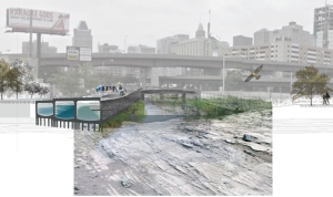
Concept for the removal of the Jones Falls Expressway, proposed by Sarah Shelton and Aja Bulla-Richards [Image from Paradoxcity.wordpress.com]
From University of Virginia comes a project by Sarah Shelton, Student ASLA, and Aja Bulla-Richards, Student Affiliate ASLA. “Alchemy of an Urban Estuary: Revealing and Transforming Infrastructure Along the Jones Falls Corridor” takes more of an environmental approach, citing water issues as a primary concern. They justify that the city’s issues with flooding in the past was due to the development encroaching upon the wetlands, which effectively destroyed the estuary’s ability to accommodate heavy rains. The benefit of replacing the Jones Falls Expressway with a restored wetland estuary is one of both ecological and cultural support. Currently, the poor water quality of Baltimore’s waterways threatens the entire region. This, as Aja and Sarah explain, is not only an ecological concern but also a social, cultural, and economic concern as well. The culvert that currently incarcerates the last mile of the Jones Falls River will, in their design, filter and store storm water. As an attraction, the Jones Falls Valley corridor will engage both sides o the city, effectively reconnecting East Baltimore with the downtown area. Similar to the remaining Cheonggye Freeway pillars in Seoul, Aja and Sarah suggest keeping some of the elevated JFX in tact as a reminder for future generations. On top of this portion, Baltimore could follow the example set by New York City’s Highline. From the elevated greenspace, people might perhaps better appreciate the wonderful view of Baltimore’s skyline that they currently only catch in small glimpses when they drive along the expressway.
From Rensselaer Polytechnic Institute in New York, student Marc Szarkowski presents his project, “Unlocking the Potential of the Jones Falls Valley Corridor.” Szarkowski’s project is more design-oriented, and very much concerned with stitching the new urban boulevard seamlessly into the existing urban fabric. Yet his proposal does not ignore the environmental potential of the corridor. Should the JFX be removed, the Jones Falls Trail could be extended all the way to the Inner Harbor. Daylighting the Jones Falls will make the waterway usable once again. In a city where the water is a major tourist draw, the Jones Falls River would be an even greater opportunity for attraction. The canal Szarkowski has illustrated is conjures romantic images of a Venetian city. His emphasis on ecological inclusion is reminiscent of an urban parks mindset. Returning nature to the city, and bringing it into the central business district, will be a huge improvement for the quality of space as well as for the health of the city. Szarkowski’s project assures that traffic will continue to flow easily. In fact, the access and connectivity will actually be improved. When the various federal highway legislations had been created, they were meant to increase mobility of the city. They failed, however, to address any mode of transportation other than the automobile. Szarkowski’s plan transforms the Jones Falls corridor into a dedicated local transit network, accommodating several different travel modes. Like Olmsted had done in Central Park, Szarkowski has separated the various transportation paths through grade dimensionality. These same grade changes providing the opportunity for retail, sunken in the canal and bordered by a promenade. In the custom of the recent “complete streets” planning movement, the corridor would provide a space for pedestrians in addition to automobiles. Szarkowski’s proposal is very in depth, he clearly has a good understanding of the existing conditions surrounding the JFX. Thus his proposal is context sensitive and woven into the urban fabric.
Whether the city takes an ecological approach, or a design-oriented approach, any step towards removing the social and ecological barrier that is the Jones Falls Expressway is a step in the right direction. Baltimore City is a water city. At one time, Baltimore thrived on the Jones Falls Valley corridor. Today, the corridor needs Baltimore to restore what has been broken. Although Baltimore’s past planning projects may not have always been kind to the Jones Falls Valley, as with most things in life, they were part of a learning process. That there has been time to reflect upon the weakness of past projects; Baltimore might reverse old plans and improve the future.
[1] Ditkoff, Anna. “How’s it Growin’?” Baltimore City Paper. Nov 12 2003. Web. 4 Dec. 2011.
[2] In response to concerns expressed in the Baltimore Brew article, “Junking the JFX”
Works Cited
- Anderson, Martin. “The Federal Bulldozer: A Critical Analysis of Urban Renewal, 1949-1962.” MIT Press. Cambridge, MASS. 1964. Print.
- Baker, Linda. “Removing Roads and Traffic Lights Speeds Urban Travel” originally titled “Detours by Design.” Scientific American Magazine. Jan 28 2009. Web. 4 Dec. 2011.
- Chan, W., Wong, S., Cohen, A., Millspaugh, M., Hellman, W., & Barrie, A. “Baltimore Highway Planning and its Effect on Planning Baltimore.” Fourteenth National Conference on Planning History of the Society for American City and Regional Planning History. Tremont Plaza Hotel, Baltimore, MD. 19 November 2011. Roundtable.
- Counihan, Harold J. “Moving Maryland Forward: A Century of Modern Road Building.” Maryland Department of Transportation: University of Maryland Printing Services. 2008. Print.
- Dickinson, Elizabeth E. “The Path of Least Resistence.” The Urban Palimpsest. Sept 30 2008. Web. 4 Dec 2001.
- Ditkoff, Anna. “How’s it Growin’?” Baltimore City Paper. Nov 12 2003. Web. 4 Dec. 2011.
- Dorsey, John. “When the Fallsway was Created.”The Baltimore Sun. Sunday Sun Magazine. 23 Feb 1964. Print.
- Flint, Anthony. “This land: the battle over sprawl and the future of America.” JHU Press, 10 April 2006. Print.
- “Jones Falls Expressway Historic Overview.” DCRoads.net. DC Roads, n.d. Web. 11 Nov 2011.
- “Junking the JFX: a dream demolition?” BaltimoreBrew.com. Baltimore Brew, 18 May 2009.
- Kay, Jane Holtz. “Asphalt Nation: How the Automobile Took Over American and How We Can Take it Back.” Berkley, CA: U California Press, 1997. Print.
- 12. Kroiz, Gabriel. “The Heart of Seoul: How One Metropolis Reclaimed the River that Ran Through It.” Urbanite Magazine. Dec 1 2006. Web. 4 Dec. 2011.
- Lynch, Kevin. “The Image of the City.” MIT Press, Cambridge, MASS. 1960. Print.
- Sandler, Gilbert. “How the city’s nickname came to be.” The Baltimore Sun. 18 Jul 1995. Web. 8 Dec 2011.
- Shelton, Sarah Noel and Aja Justine Bulla-Richards. “Alchemy of an Urban Estuary: Revealing and Transforming Infrastructure Along the Jones Falls Corridor.” American Society of Landscape Architects. 2010. Web. 17 Nov. 2011.
- Smith, Daniel S. and Paul Cawood Hellmund. “Ecology of Greenways.”Minnesota, MN: U of Minnesota Press, 1993. Print.
- “Something About Jones’ Falls Valley: A Brief Discourse in the Feasibility of Converting it into a Public Park.” The Baltimore Sun. The Evening Sun. 27 March 1940. Print.
- Spirn, Anne Whiston. “Granite Garden: Urban Nature and Human Design.” New York: Basic Books, 1984. Print.
- Swope, Jane Tinsley. “Stream that Shaped a City: The Jones Falls Story.” The Baltimore Sun. Sept 1957. Print.
- Szarkowski, Marc. “Unlocking the Potential of the Jones Falls Valley Corridor.”Envision Baltimore. Sept 7 2011. 7 Sept 2011.
- Teaford, Jon C. “The Rough Road to Renaissance: Urban Revitalization in America, 1940-1985.” Johns Hopkins University Press, 1990. Print.
- Board, 1956. Print.
- Wilk, Cavan.“Tearing Down a Baltimore Highway Provide Lessons for DC.”GreaterGreaterWashington.org. 12 June 2009. Web. 26 Nov 2011.
- Wong, Sidney. “Architects and Planners in the Middle of a Road War: The Urban Design Concept Team in Baltimore, 1966–1971.”


